Major Land Resource Area 131A
Southern Mississippi River Alluvium
Accessed: 10/09/2025
Description
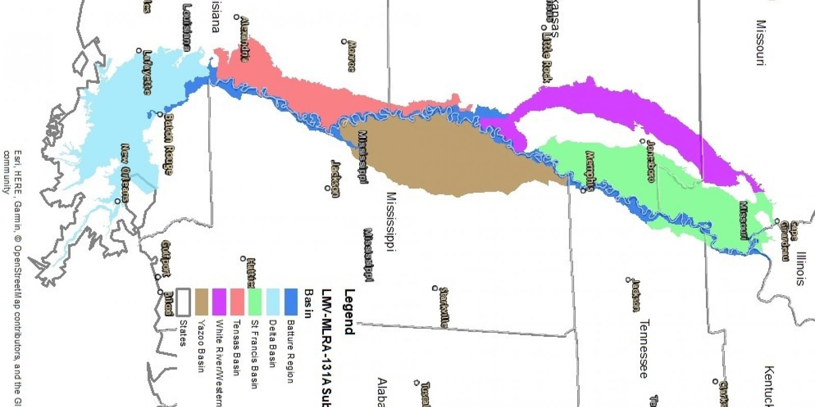
MLRA 131A, Southern Mississippi River Alluvium, is in Louisiana (32 percent), Arkansas (26 percent), Mississippi (26 percent), Missouri (12 percent), Tennessee (3 percent), and Kentucky (1 percent). A small part of Illinois also is in the area. This MLRA makes up about 29,555 square miles (76,585 square kilometers). It includes the towns or cities of Lake Providence, Morgan City, and Houma, Louisiana; Greenville, Yazoo City, and Clarksville, Mississippi; Eudora, Helena, and West Memphis, Arkansas; Caruthersville, Kennett, and Sikeston, Missouri; and the west edge of Memphis, Tennessee. The cities of Baton Rouge and New Orleans, Louisiana, are just outside this area. This area makes up most of the Mississippi Alluvial Plain Section of the Coastal Plain Province of the Atlantic Plain. It is on the alluvial plain along the lower Mississippi River, south of its confluence with the Ohio River. The landforms in the area are level or depressional to very gently undulating alluvial plains, backswamps, oxbows, natural levees, and terraces. The parts of the MLRA south of Baton Rouge, Louisiana, are on a deltaic plain. The Mississippi River has the third largest drainage basin in the world, exceeded in size only by the watersheds of the Amazon and Congo Rivers. It drains 41 percent of the 48 contiguous states of the United States. The basin covers more than 1,245,000 square miles, includes all or parts of 31 states and two Canadian provinces, and roughly resembles a funnel which has its spout at the Gulf of Mexico. Waters from as far east as New York and as far west as Montana contribute to flows in the lower river. For the purpose of ecological site concepts, the MLRA was separated by the Technical team into six sub-regions based on various assemblages of data reviewed.
Key publications
Next steps
-
1
Select an ecological site
Select an ecological site using the list, keys, photos, briefcase, or quick search option located on this page. -
2
Explore the ecological site description
Next, learn more about the selected ecological site and its characteristic dynamics by browsing the ecological site description and exploring alternative state and transition model formats.
Ecological site list
-
i
Key Characteristics
- St Francis Basin
- Backswamp
- Very Deep, Poorly Drained Clayey Alluvium
- Level Surfaces (Talfs)
-
i
Key Characteristics
- St Francis Basin
- Backswamp
- Very Deep, Poorly Drained Clayey Alluvium
- Low Ridges (Rises)
-
i
Key Characteristics
- St Francis Basin
- Backswamp
- Poorly to Somewhat Poorly Drained Clayey Over Loamy
-
i
Key Characteristics
- St Francis Basin
- Pleistocene Valley Train
- Somewhat Excessively to Excessively Drained Ridges and Braid Bars
-
i
Key Characteristics
- St Francis Basin
- Pleistocene Valley Train
- Moderately Well to Well Drained Interfluves
-
i
Key Characteristics
- St Francis Basin
- Pleistocene Valley Train
- Poorly to Somewhat Poorly Drained Interfluves
-
i
Key Characteristics
- St Francis Basin
- Pleistocene Valley Train
- Poorly Drained Remnant Channels
-
i
Key Characteristics
- St Francis Basin
- Holocene Meander Belts and Floodplains
- Somewhat Excessively to Excessively Drained
-
i
Key Characteristics
- St Francis Basin
- Holocene Meander Belts and Floodplains
- Old Natural Levee
- Moderately Well to Well Drained
-
 ProvisionalF131AY210AR/F131AY210ARSt. Francis - Old Moderately Wet Natural Levee and Meander Scroll Foresti
Key Characteristics
- St Francis Basin
- Holocene Meander Belts and Floodplains
- Old Natural Levee
- Somewhat Poorly Drained
-
i
Key Characteristics
- St Francis Basin
- Holocene Meander Belts and Floodplains
- Old Natural Levee
- Poorly Drained
-
ProvisionalF131AY212AR/F131AY212ARSt. Francis - Recent Loamy Natural Levee and Meander Scroll Foresti
Key Characteristics
- St Francis Basin
- Holocene Meander Belts and Floodplains
- Recent Natural Levee
- Well Drained
-
ProvisionalF131AY213AR/F131AY213ARSt. Francis - Recent Moderately Wet Natural Levee and Meander Scroll Foresti
Key Characteristics
- St Francis Basin
- Holocene Meander Belts and Floodplains
- Recent Natural Levee
- Somewhat Poorly to Moderately Well Drained
-
ProvisionalF131AY214AR/F131AY214ARSt. Francis - Recent Wet Natural Levee and Meander Scroll Foresti
Key Characteristics
- St Francis Basin
- Holocene Meander Belts and Floodplains
- Recent Natural Levee
- Poorly to Somewhat Poorly Drained
-
i
Key Characteristics
- Yazoo Basin
- Backswamp
- Ponded Depressions
-
i
Key Characteristics
- Yazoo Basin
- Backswamp
- Very Deep, Poorly Drained Clayey Alluvium
- Level Surfaces (Talfs)
-
i
Key Characteristics
- Yazoo Basin
- Backswamp
- Very Deep, Poorly Drained Clayey Alluvium
- Low Ridges (Rises)
-
i
Key Characteristics
- Yazoo Basin
- Backswamp
- Somewhat Poorly to Poorly Drained Clayey Over Loamy
-
i
Key Characteristics
- Yazoo Basin
- Old Natural Levees
- Somewhat Excessively to Excessively Drained
-
i
Key Characteristics
- Yazoo Basin
- Old Natural Levees
- Moderately Well to Well Drained
-
 ProvisionalF131AY307MS/F131AY307MSYazoo - Old Moderately Wet Natural Levee and Meander Scroll Ridge Foresti
Key Characteristics
- Yazoo Basin
- Old Natural Levees
- Somewhat Poorly Drained (Fine-silty)
-
i
Key Characteristics
- Yazoo Basin
- Old Natural Levees
- Somewhat Poorly to Poorly Drained (Fine particle size)
-
ProvisionalF131AY309MS/F131AY309MSYazoo - Recent Sandy Natural Levee and Meander Scroll Ridge Foresti
Key Characteristics
- Yazoo Basin
- Recent Natural Levees
- Excessively Drained
-
ProvisionalF131AY310MS/F131AY310MSYazoo - Recent Loamy Natural Levee and Meander Scroll Ridge Foresti
Key Characteristics
- Yazoo Basin
- Recent Natural Levees
- Well Drained
-
ProvisionalF131AY311MS/F131AY311MSYazoo - Recent Moderately Wet Natural Levee and Meander Scroll Ridge Foresti
Key Characteristics
- Yazoo Basin
- Recent Natural Levees
- Moderately Well to Somewhat Poorly Drained
-
i
Key Characteristics
- Yazoo Basin
- Recent Natural Levees
- Somewhat Poorly (Clayey over Loamy) to Poorly Drained
-
i
Key Characteristics
- Yazoo Basin
- Valley Train
- Moderately Well to Well Drained Ridges and Braid Bars
-
 ProvisionalF131AY401LA/F131AY401LATensas Basin - Frequently Flooded Ponded Very Poorly Drained Oxbows and Swalesi
Key Characteristics
- Tensas Basin
- Frequently Flooded
- Very Poorly Drained
-
i
Key Characteristics
- Tensas Basin
- None to Frequently Flooded
- Poorly Drained
- Backswamp
-
i
Key Characteristics
- Tensas Basin
- None to Frequently Flooded
- Poorly Drained
- Ridge Swale
-
i
Key Characteristics
- Tensas Basin
- None to Frequently Flooded
- Somewhat Poorly Drained
- Bottomland
-
i
Key Characteristics
- Tensas Basin
- None to Frequently Flooded
- Somewhat Poorly Drained
- Wet Toe Slope
- Tensas Basin
- None to Occasionally Flooded
- Well Drained
-
i
Key Characteristics
- Tensas Basin
- Frequently Flooded
- Excessively Drained
-
 ProvisionalF131AY501LA/F131AY501LADelta Plain - Frequently Flooded Ponded Very Poorly Drained Oxbows and Swalesi
Key Characteristics
- Delta Basin
- Frequently Flooded
- Very Poorly Drained
-
i
Key Characteristics
- Delta Basin
- None to Frequently Flooded
- Poorly Drained
-
i
Key Characteristics
- Delta Basin
- None to Frequently Flooded
- Somewhat Poorly Drained
-
i
Key Characteristics
- Delta Basin
- None to Occasionally Flooded
- Well Drained
-
i
Key Characteristics
- Batture Region
- Rare to Frequently Flooded
- Excessively to Very Poorly Drained
-
ProvisionalF131AY602MS/F131AY602MSBatture - Frequently Flooded Very Poorly Drained Ponded Oxbow and Swale Foresti
Key Characteristics
- Batture Region
- Frequently Flooded
- Very Poorly Drained
-
i
Key Characteristics
- Batture Region
- Frequently Flooded
- Poorly Drained
-
i
Key Characteristics
- Batture Region
- Occasional to Frequently Flooded
- Somewhat Poorly to Moderately Well Drained
-
i
Key Characteristics
- Batture Region
- Occasional to Frequently Flooded
- Excessively to Well Drained
-
i
Key Characteristics
- Batture Region
- Frequently Flooded
- Excessively Drained

Ecological site map
Basemap
Find me
Find point
Full screen
Zoom in to display soil survey map units for an area of interest, and zoom out to display MLRAs. Select a map unit polygon to view ecological sites correlated to that map unit. View a brief description of an ecological site by clicking on its name in the map popup. Soil survey correlations may not be accurate, and ecological site classification of a location should always be verified in the field. Each selection may require the transfer of several hundred KB of data.
Ecological site keys
Ecological site photos
Print Options
Sections
Font
Other
Briefcase
Add ecological sites and Major Land Resource Areas to your briefcase by clicking on the briefcase (![]() ) icon wherever it occurs. Drag and drop items to reorder. Cookies are used to store briefcase items between browsing sessions. Because of this, the number of items that can be added to your briefcase is limited, and briefcase items added on one device and browser cannot be accessed from another device or browser. Users who do not wish to place cookies on their devices should not use the briefcase tool. Briefcase cookies serve no other purpose than described here and are deleted whenever browsing history is cleared.
) icon wherever it occurs. Drag and drop items to reorder. Cookies are used to store briefcase items between browsing sessions. Because of this, the number of items that can be added to your briefcase is limited, and briefcase items added on one device and browser cannot be accessed from another device or browser. Users who do not wish to place cookies on their devices should not use the briefcase tool. Briefcase cookies serve no other purpose than described here and are deleted whenever browsing history is cleared.
Ecological sites
Major Land Resource Areas
The Ecosystem Dynamics Interpretive Tool is an information system framework developed by the USDA-ARS Jornada Experimental Range, USDA Natural Resources Conservation Service, and New Mexico State University.